Jump to:

Description History Long ​Route Short ​Route Safety ​and ​Practical ​Arrangements


Description

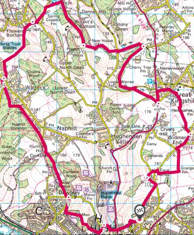
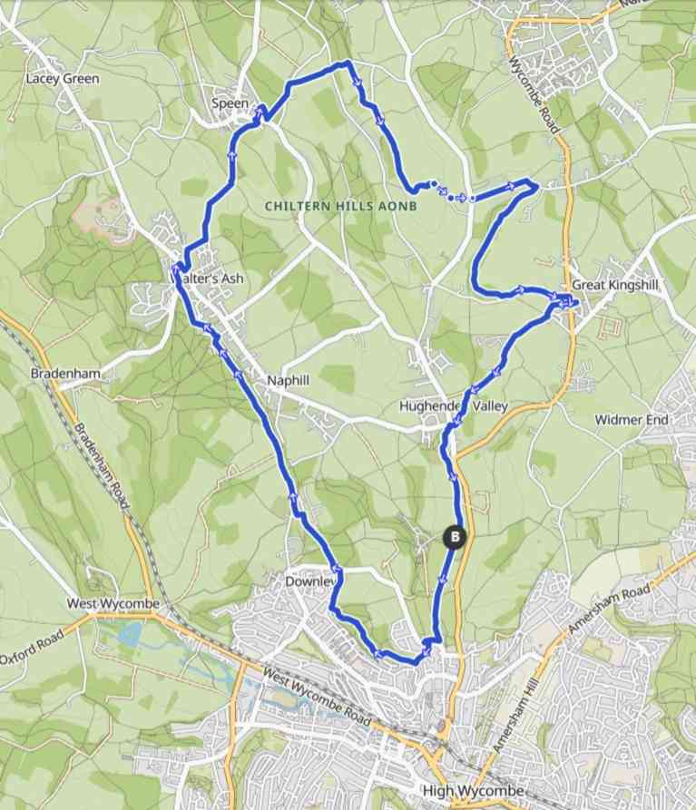
A self-guided walk around the parish boundary starting and finishing at the church. The whole boundary is more than 12 miles, (plus the distance from church out to the boundary and back again), which is rather too far for some people, so we have a Long Route and a Short Route which together cover the whole boundary. It’s not intended as an endurance test or race, but for enjoyment and spiritual refreshment. Maybe one day we’ll organise a race, or maybe some keen souls will arrange to walk all the way round.

Pray: You are encouraged to pray as you walk the boundary: for all who live within the parish on your one side, and for the whole wide world on your other side. You can talk as you walk, but do walk in silence for a while and see what God shows you.

Nature's Treasure Hunt: Don’t bother looking for the four-leafed clover or the pot of gold at the end of the rainbow, but keep eyes and ears open and camera/mobile at the ready: beautiful flowers (garden and wild), enthusiastic birdsong, largest creepy-crawly, crops sprouting, an unusual cloud, the deepest puddle, deer grazing, kites circling. Talk with each other, but more importantly listen; smile at passers-by, or show them your treasures, and at the picnic share your treasures with walkers whom you hardly know.

Cairn: A cairn is a man-made pile or stack of stones raised for a purpose, usually as a trail marker or a point of significance. For us, our cairn represents the end of our walk, back at church, the focal point of our parish.

Find a 'pilgrim’s stone' along your walk. Maybe choose two stones; one for another person who has not been able to walk the footpaths like you. Bring your stones to the Church and place them somewhere significant in the churchyard and take a few moments in reflection. We previously built a temporary cairn of such stones, but it no longer exists.

Before you start: use the links to the route maps (below); leave your car safely locked at the church car park; visit the toilet at church: such facilities are very limited on these routes! And say a quick prayer before you start.

History

We follow the ancient tradition of “beating the bounds”: walking along the parish boundary to remind everyone where the boundary lies.

On Easter Monday 2022 and on Spring Bank Holiday Monday 2025 the church organised a Parish Boundary Walk with a picnic at Great Kingshill Cricket Ground. Two routes were devised “Long” and “Short”, both starting at church and converging at  the GK Cricket Ground. After the Picnic and a game of French Cricket  to use up any surplus energy, both routes proceeded down to church via Boss Lane. At church the walkers put together stones which they had collected en route to make a small cairn. There was a short ceremony and prayers to thank God for a safe journey, great friendship, and a wonderful day out in the countryside.

The purpose of those two events was partly for sheer enjoyment, but partly to encircle the parish in prayer. As we walked we prayed one the one hand for all the people and situations in the villages of our parish, and on the other hand for the big wide world outside the parish and our concern for its problems and our Christian care for all its peoples.

The two routes are now available for anyone and everyone to walk and to pray as you see fit. May the Lord bless you and keep you safe.

The true Hughenden parish boundary is shown in the image below, outlined in black.

Nowadays the true boundary doesn’t have rights of way all along it, so our walking route will follow along proper tracks and roads which are as near as we can reasonably follow the boundary and which are pleasant to walk along. The approximate walking route is shown in the other image for comparison, outlined in red.

You can see the shape is not exactly the same. If you ever want to be certain whether a particular place or building is within the parish, look online at www.achurchnearyou.com.

Parish Boundary

Walking Route

Routes

Links are provided below for each route, offering GPX files containing a digital version of the routes to download to your preferred mapping app on your mobile device. A printable pdf map and route description are also available to download below.

To use the GPX map, you will need a compatible mapping app on your phone. Find out more at www.advnture.com/​​features/​​what-is-a-gpx-file. Two apps which we have used successfully are Locus and Kamoot.

The Long Route is around 19 km (12 miles) starting and finishing at the church, (marked as “B”). The route takes in Downley, Naphill, Walter's Ash, Speen, Bryant's Bottom, Great Kingshill and Hughenden Valley. It will require a reasonable level of fitness or determination, taking you up and down the valleys with around 520 m of elevation change, (260m up and 260m down). The whole route is estimated to take around 5 to 6 hours to complete depending on your walking speed.

The Short Route is around 11 km (7 miles) starting and finishing at the church. The route takes in, Green Hill, Four Ashes, Widmer End, Great Kingshill and Hughenden Valley. It will require a reasonable level of fitness or determination, taking you up and down the valley with around 260 m of elevation change, (130m up and 130m down). The whole route is estimated to take around 3 hours to complete depending on your walking speed..

Safety and Practical Arrangements

  1. 1. Participation is at your own risk. There will be no route marshals and no special signboards; you’re responsible for your own safety just as you would if you were going out for a walk or picnic that you’d planned yourself. No first aiders are supplied. Please ensure you carry sufficient water and food. Please cross roads very carefully; visibility in some places is limited.

  2. The routes are definitely not suitable for wheelchairs or buggies.

  3. Toilets are available for use at church.

  4. Dogs are welcome. Just keep your dog under good control as you usually do.

See Also